Conceptual Plans
NYC Parks sometimes undertakes planning processes on the scale of an entire neighborhood or open space system. In other cases, Parks works to create plans for major flagship parks that have never had dedicated planning efforts. These large-scale, community-driven planning processes are known as Conceptual Plans, or sometimes Master Plans. A conceptual plan can be thought of as a long-term strategy to address a variety of issues: Accessibility and neighborhood connections; amenities and facilities; ecological sustainability; and restoration of historic assets are a few.
Conceptual plans are an important part of NYC Parks' planning portfolio, and offer an important opportunity for communities to take part in the shaping of their parks. These plans create a long-term vision for parks, and inform how capital projects are prioritized to best suit their communities. Conceptual plans often include cost estimates for proposed concepts, to help guide future fundraising efforts.
A few examples of Parks' Conceptual Plans are below.
Destination: Greenways!
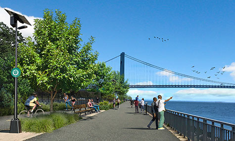
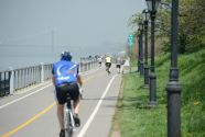
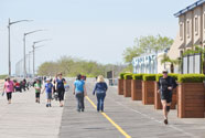
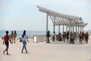
This conceptual study focuses on creating an improved greenway experience within New York City parks so that greenways are not simply connections between places, but also enjoyable destinations in themselves. The two concept plans propose design solutions to create continuous, safe, and enjoyable greenways for all New Yorkers. Extensive community engagement helped inform the proposed improvements along the routes – one along the waterfront in southwest Brooklyn and the other connecting parks in central and eastern Queens. The concept plans were developed in close partnership with the New York City Department of Transportation to propose safe on-street connections between these park segments. The conceptual study was completed in Fall 2021 and presented in community report-back sessions in February 2022.
Download the Destination: Greenways! conceptual plan for eastern Queens
Download the Destination: Greenways! conceptual plan for Brooklyn
Harlem River Watershed Plan
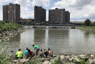
Historically, the Harlem River was a valuable ecological resource and attracted boaters, swimmers, and countless others for recreational activities. Unfortunately, industrialization along its shoreline throughout the 19th & 20th centuries fragmented natural habitats, reduced water quality, and cut off public access to the waterfront in the Bronx. NYC Parks worked with the Bronx community to create a management plan for the Harlem River watershed that will restore the shoreline, improve water quality and habitat health, and promote public access to the river.
Harlem River Brownfield Opportunity Area Nomination Report
The Harlem River Brownfield Opportunity Area Nomination Report explores the potential for reviving a nearly five mile stretch of the Harlem River waterfront on the Bronx side. Funded by the New York State Department of State’s Brownfield Opportunity Area Program, the Bronx Council for Environmental Quality partnered with NYC Parks to produce this report. It reaffirms the community vision for a dynamic district of waterfront parks connected to one another, tied into the greater greenway system, and linked with upland neighborhoods.
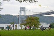
Riverside Park Master Plan
A thoughtfully designed combination of boulevard, scenic landscape, railway, parkway, and shoreline, Riverside Park offers a national model for the creation of vibrant, urban waterfront parks. As we look forward to the future of the jewel of Manhattan’s west side, this new Master Plan, written with intensive community input, sets a vision of strengthened park infrastructure and enhanced access.
Shoreline Parks Plan
The U.S. Army Corps of Engineers has proposed the construction of a protective seawall from Fort Wadsworth to Great Kills Park. Recognizing the effect this important project will have on our parkland, NYC Parks working with the community developed the Shoreline Parks Plan to guide the redevelopment of our shoreline parks to work with the proposed flood protection. We worked with the community to develop plans to reconfigure our open space and recreational amenities such as sports fields, buildings and playgrounds to take advantage of this future planned setting.
Van Cortlandt Park
New York City purchased the Van Cortlandt family estate in 1876, but made no comprehensive plan for the park. From the 1930s to the 1950s, the construction of three major highways fragmented the park and constricted community access to its hills, forests, fields and wetlands. This comprehensive Master Plan aims to knit the park back together and restore its natural beauty. It proposes recreational opportunities for all neighboring communities. The plan charts a clear course of action that will coordinate efforts over the next twenty years between agencies, nonprofit partners, elected officials and community groups to complete privately and publicly funded projects and programs in Van Cortlandt Park.

Rockaway Parks
This plan addresses the agency's open space goals in the wake of Hurricane Sandy: to replace facilities lost from the storm, improve existing parks across the Rockaway Peninsula and Broad Channel, and create a long-term vision that integrates resiliency and enhances community protection. The Conceptual Plan complements ongoing reconstruction and resiliency efforts by integrating recreational facilities adjacent to the boardwalk and providing a broader vision for resilient parks and open space. The Conceptual Plan reflects extensive community input, including discussions with Rockaway and Broad Channel residents that began in the spring of 2013.
High Rock Park
Often referred to as one of the most tranquil places in New York City, Staten Island's High Rock Park is noted for its quiet ponds and deep woods. Hosting the Greenbelt Conservancy’s headquarters, the park has been recognized as a Natural Environmental Education Landmark by the United States Department of the Interior. The High Rock Conceptual Plan aims to improve the visitor experience to High Rock by updating and consolidating administrative and educational buildings; improving trails, landscaping, and interpretive elements; and developing programming that builds on High Rock's legacy as an environmental education landmark. Developed in cooperation with the Greenbelt Conservancy, environmental educators, neighbors, and others in the community, the High Rock Conceptual Plan was completed in Fall 2014.
Crotona Park
NYC Parks is engaged in a process to identify projects and programs that will address community concerns and recreational needs as well as restore the landscape beauty, structures and ecology of Crotona Park in the South Bronx. The resulting Master plan will be used to coordinate the efforts of elected officials, NYC Parks, other City agencies, community volunteers and non-profit partners over a twenty year period.
Northern Manhattan Parks
Northern Manhattan offers extensive recreational facilities, playgrounds, ballfields, sports courts, and greenways. Its more than 600 acres of parks include unique ecological and geological features, historic landscapes, forests, wetlands, saltwater marshes, and more than nine miles of waterfront. From spring 2010 through fall 2011, NYC Parks worked with Community Board 12, and an Advisory Council to prepare a master plan for the parks north of 155th Street in Manhattan. The plan aimed to foster a shared understanding of the opportunities and challenges facing the network of parks and to guide the next 20 years of park revitalization.
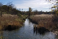
Staten Island's North Shore
Staten Island’s North Shore is a valued ecological, economic, and social resource that provides a wealth of social, recreational, educational, and environmental opportunities. This is the first planning effort for the whole north shore that will focus primarily on natural resources. The plan is aimed at protecting, restoring, and enhancing natural resources, managing stormwater, and promoting public enagement and education.
East Harlem
The Vision Plan for a Resilient East Harlem, released December 2019, presents ideas on how East Harlem can be made a stronger and safer community in the face of a changing climate. The Plan highlights the role NYC Parks can play in responding to climate change, and opportunities for us to partner with other agencies and stakeholders to further neighborhood resiliency..
Hart Island Transportation Study
Hart Island is New York City’s public cemetery, located in the Long Island Sound to the east of City Island in the Bronx. At present, the island is difficult to access due to its isolated location and limited ferry connection to the rest of the city. This study analyzed existing transportation access to Hart Island and developed conceptual projects for improving transportation access to the island for those traveling by public transit and by private automobile. Past visitors and stakeholders of Hart Island were surveyed to help develop the conceptual projects, and these concepts were shared at a public meeting in March 2022. The study was completed in partnership with the Department of Transportation, the Human Resources Administration, the Office of the Chief Medical Examiner, and the NYC Economic Development Corporation. The final report was delivered to the New York City Council on July 1, 2022 as mandated by Local Law 211 of 2019.
%7Cutmcsr%3D(direct)%7Cutmcmd%3D(none)%3B%2B__utmv%3D86347125.-%3B)