Before They Were Parks
Pick any public park, and it has a story to reveal about what it once was and how it came to be. It may be lush and green now, but at some point in its past it might have been a warehouse, tenement, estate, reservoir, landfill, cemetery or jail. The route from private ownership to public amenity is typically long and arduous. Here we feature a fraction of the countless scenarios that have marked the city’s never–ending quest for parkland in a densely built metropolis.
An exhibit on this subject was on display in the Arsenal Gallery from June 23, 2010–September 9, 2010.
Select a borough:
Bronx
Claremont Park, Bronx
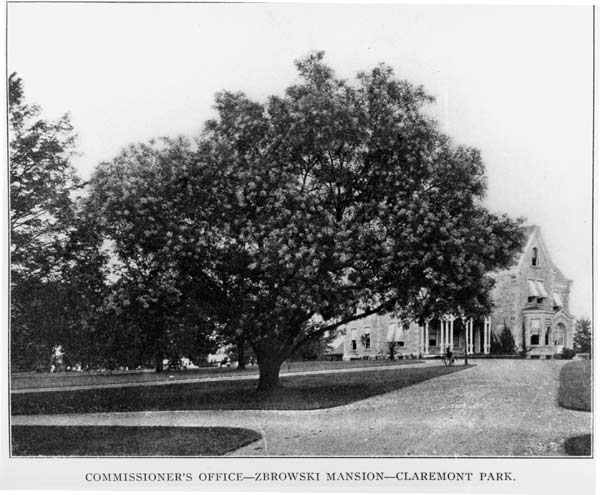
The area that is now Claremont Park was once part of the Morris family estate, founded in 1679. The Morris family lived on the land during the Colonial era; the most famous Morris, Gouverneur Morris (1752–1816), wrote the final draft of the Constitution. Gouverneur Morris II (1813–1888) auctioned off much of his land in 1848 and wealthy newlyweds Elliott and Anna Zborowski de Montsaulain acquired a parcel in the northern portion of the former Morris property.
In 1859, the Zborowski de Montsaulains built the Claremont mansion and developed the grounds with terraced lawns, descending to the Mill Brook (now Webster Avenue).
After the site became a park, the mansion was converted for use as the local administrative headquarters of the Bronx Parks Department. The mansion was razed in 1938 and replaced with a gazebo.
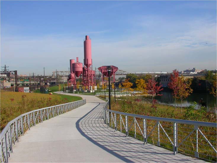
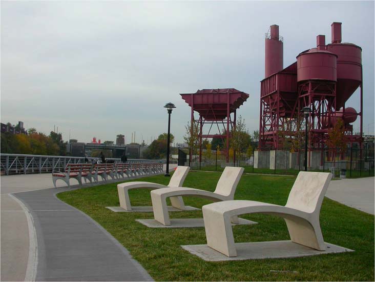
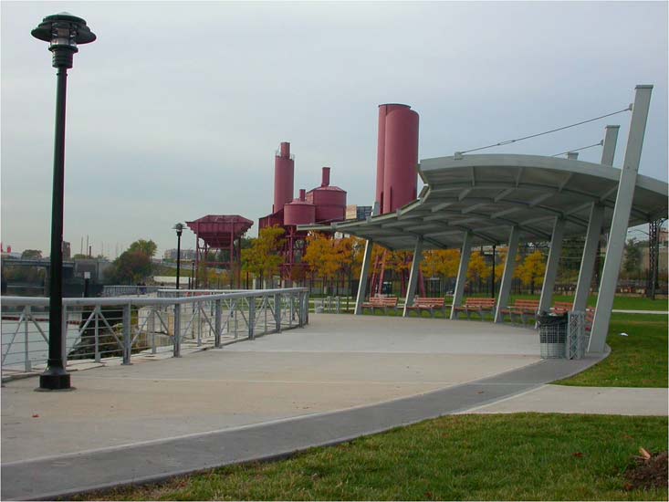
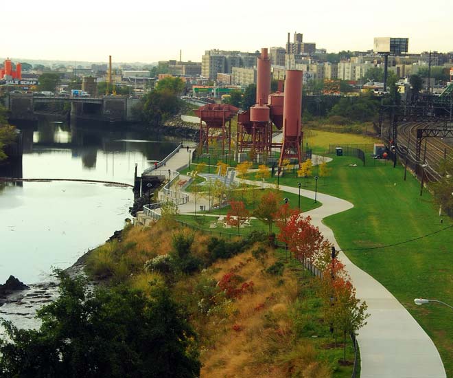
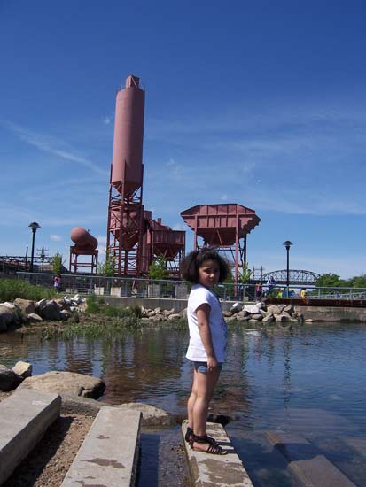
Concrete Plant Park, Bronx
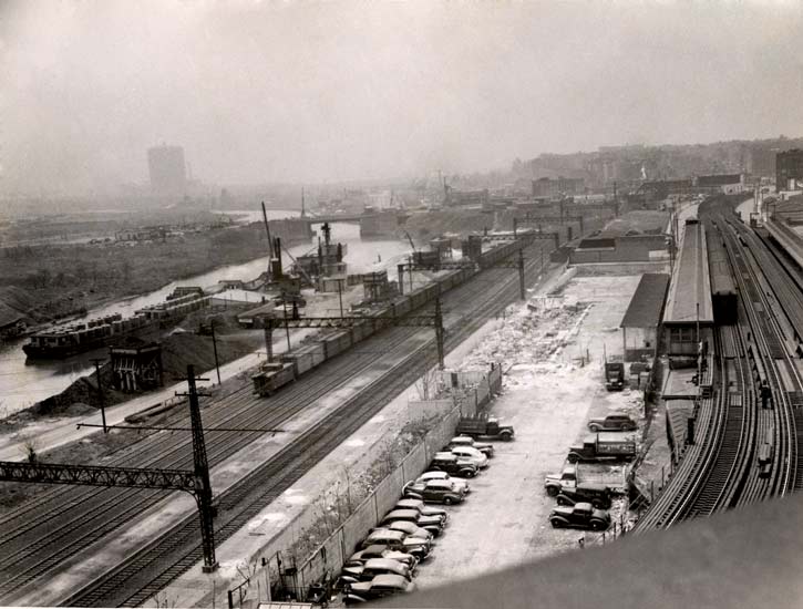
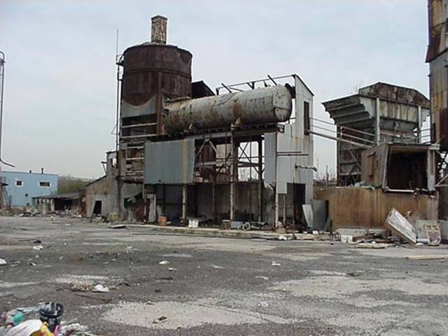
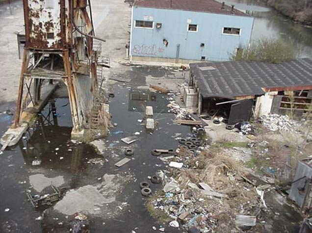
The western side of the southern portion of the Bronx River was used by the Transit Mix Concrete Corporation from 1945 to 1987 as a concrete plant. The abandoned eyesore was saved from the auction block and redirected to park use by a community-based effort led by Youth Ministries for Peace and Justice and the Point Community Development Corporation, who fought to have the site cleaned of toxic materials and waste, and converted for active and passive recreation. In partnership with the Parks Department and the Bronx River Alliance, these groups spearheaded a clean-up of the site from 2000 to 2005, and its ultimate conversion to a park in 2009.
Click on an image to view a larger size and more information
Henry Hudson Parkway, Bronx
Before the construction of the Henry Hudson Parkway in the Bronx, the areas of lower Riverdale and Spuyten Duyvil were fairly isolated villages. Many of the properties in these areas were condemned. The Henry Hudson Bridge and Bronx portions of the Henry Hudson Parkway opened in the spring of 1938, linking “Canal Street to Westchester,” as was written in the opening day brochure. Within a matter of a few years millions of passenger vehicles took advantage of the parkway, which cut travel time from lower Manhattan to Westchester by over 40 minutes. At the time, the bridge and its 800 foot long central span formed the longest plate girder, fixed–steel arch in the world.
Click on an image to view a larger size and more information


Bartow–Pell Mansion and Pelham Bay Park, Bronx
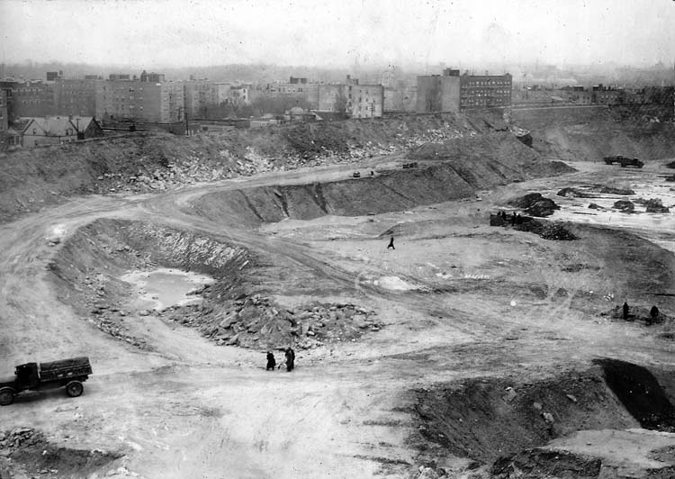
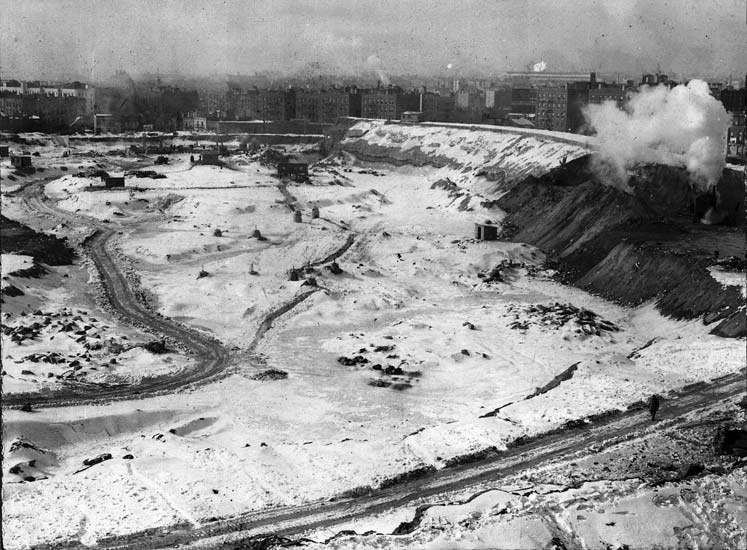
The city’s largest park, Pelham Bay Park also features a rich and varied history. Siwanoy Native Americans originally inhabited this area, followed by a short–lived English colony founded by Anne Hutchinson (for whom nearby Hutchinson River is named) in what is now the northwest corner of this park. In the 1930s, the Parks Department under Commissioner Robert Moses completed one of the most impressive public works projects by filling in the area between Hunter and Twin Islands in the Long Island Sound with three million cubic yards of landfill to craft Orchard Beach.
Numerous estates made up the bulk of the land in the nineteenth century, one of which is now known as Bartow–Pell Mansion. Englishman Thomas Pell purchased 50,000 acres of land from the Siwanoy in 1654; during the Revolutionary War, Pell's land was part of the buffer between the British–held Manhattan and rebel–held Westchester. The original house, completed in 1670 by Pell’s nephew, Sir John Pell, was destroyed during the American Revolution. Robert Bartow, a Pell descendant, purchased the land in 1836, building the Bartow Mansion, which remained in the family until 1888 when the City acquired the estate. The mansion still sits on Shore Road, and has been home to the Bartow–Pell Mansion Museum since 1946.
Click on an image to view a larger size and more information


Learn More
Historic House Trust of New York City: Bartow-Pell Mansion Museum
Vault Hill, Van Cortlandt Park, Bronx
Vault Hill sits on a rocky outcrop of land 169 feet above sea level in Van Cortlandt Park. The area served as an outpost for the Mohicans, members of the Lenape confederation, before Dutch settler Adrian Van Der Donck staked his claim to the area in 1646 and Jacobus van Cortlandt purchased the first parcel of land in his estate in 1694. His son Frederick van Cortlandt directed the construction of the house that now serves as an interpretive museum, but died in 1749, shortly before its completion. In accordance with his will, a burial vault was constructed for his remains and those of his descendants. In addition to their remains, the van Cortlandt family burial vault was used to secure family records at the onset of the Revolutionary War. In 1888 the house and grounds passed to the city to serve as a public park.
Click on an image to view a larger size and more information


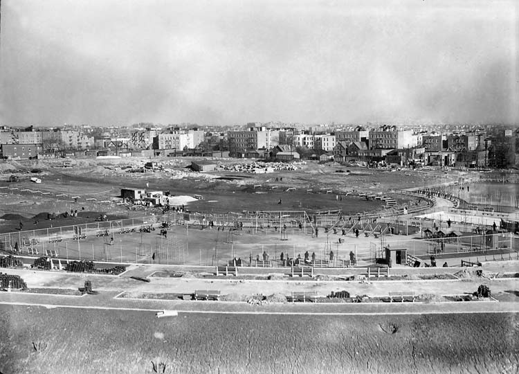
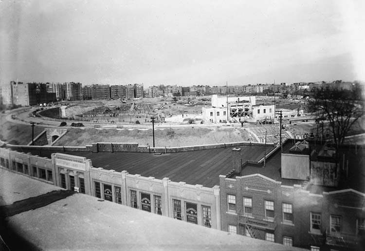
Williamsbridge Oval, Bronx
Located in the Norwood section of the Bronx, the Williamsbridge Receiving Reservoir was a natural lake that in 1888 was transformed into a reservoir. It had a capacity of 120 million gallons of water and was built to supply the areas of the Bronx not served by the Old Croton Aqueduct or the upstate reservoir at Kensico. By 1919 the reservoir was relegated only to backup use, and by 1925 was no longer needed and the site was then transferred to Parks. The oval reservoir was drained and filled in, and converted to an athletic complex that opened in 1934 that included a running track, football and baseball fields, 16 tennis courts, two playgrounds and a field house.
Related Links
Parks History Historical Signs Capital Projects Park of the Month
%7Cutmcsr%3D(direct)%7Cutmcmd%3D(none)%3B%2B__utmv%3D38354255.-%3B)