Seton Falls Park Hiking Trails
Seton Falls Park is a destination for adventure seekers, nature lovers, and history buffs alike. Magnificent cliffs, beautiful lawns, scenic overlooks, meandering forest pathways, and countless picnic areas make it a sanctuary from the city. It is composed of 130 acres of both natural forest and recreational space.
Twenty-nine acres of the Seton estate were assigned to Parks on June 11, 1930. Additional lands were assigned to Parks in 1983 and 1985. The western portion of the park was preserved as mature forest, mostly undisturbed since the time of the American Revolution.
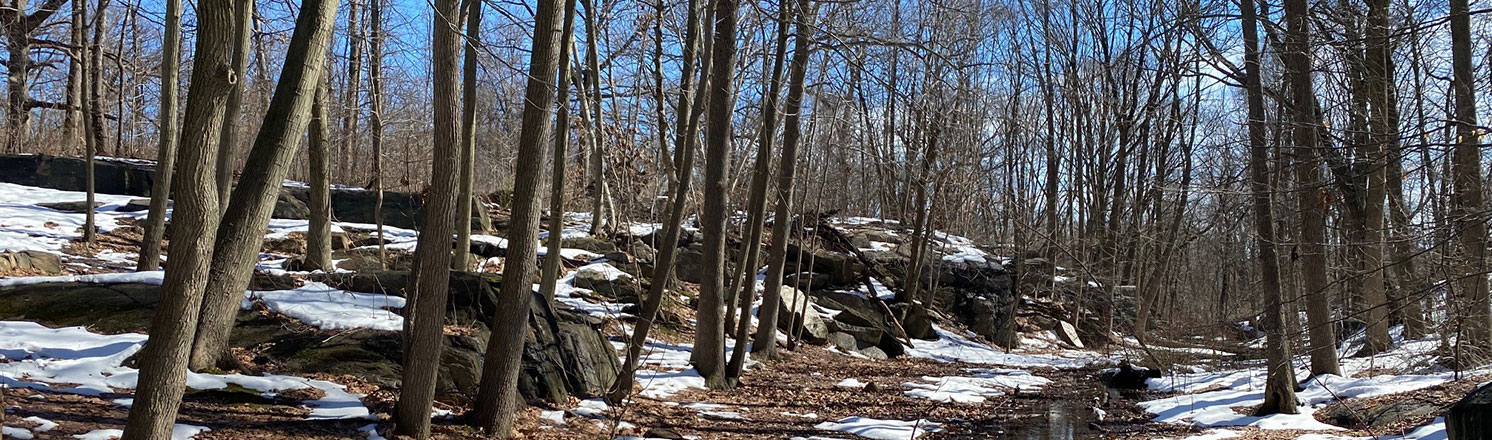
The park was formed more than 15,000 years ago at the end of the Ice Age. The recession of glaciers left rich deposits of soil and stone, the foundation of the park’s current ecology. Now containing over 30 wooded acres, the natural area is defined by Rattlesnake Creek. The freshwater wetlands are fed by this small, forested stream, which is extremely rare in New York City and are critical areas for a variety of aquatic organisms. Together the wetland and forest ecosystems provide habitat to over 30 species of birds. Floodplain forest is present along Rattlesnake Creek, as are cattail marsh and sedge meadow, at the bottom of a sheer, rocky ravine.
Orange Nature Path: This is a smooth and level pathway that runs north and south on the west side of the park and is over a half-mile in length. It is bordered by the Boeller Avenue entrance at one end and at E. 233 Street at the other end. This easy path has portions that are paved and portions that are dirt with a fine gravel top layer. The pathway affords views down into the ravine created by Rattlesnake Creek, as well as views along the path itself at several points where glacial remains from the last ice age can be found.
Blue Scenic Through Trail: The 0.5-mile Blue Trail traverses the park from the northwest corner near High Rock Playground to the southeast area of the park exiting at Marolla Place and Boeller Avenue. There is also a side access point from the Orange Trail that leads you to the midway point of the blue trail and the center of the park’s natural area. This scenic route brings you to overlooks of Rattlesnake Creek ravine and the falls from where Seton Falls gets its name.
From the north end, the trail starts with an overlook of the creek and then travels through forest dominated by red oak (Quercus rubra) and then a sweetgum (Liquidamber styraciflua) forest with a spicebush (Lindera benzoin)/ arrowwood (Viburnum dentatum) understory. It circumvents the open marsh at the north end of the park and enters a diverse species forest with terrain that is sloped in places, level in others, and rocky in spots. It opens up to a forest closed canopy forest with little vegetation underneath just to the east of Rattlesnake Creek and to a viewpoint of the ravine. Continue south along the blue trail and you will skirt through the southern marsh area and come back up to intersect with the beginning of the Orange Trail at the south end of the park at Boeller Ave and Marolla Place.
Red "Loop" Trail: This short trail is a little over a quarter-mile in length and located in the north-eastern section of the park. It passes through a large, closed forest with black cherry (prunus serotina), red oak (Quercus rubra) and bitternut hickory (carya cordiformis) spread throughout. Next to the paths, you can also find planted arrowwood (Viburnum dentatum) and blackhaw (Viburnum prunifolium). Enter the trail at one of two signed park entrances near the corner of East 233rd Street and Seton Ave and follow the loop trail around to come out the other entrance a few steps away from where you began on East 233rd.
Interactive Map
![]() Orange Nature Path
Orange Nature Path
![]() Blue Scenic Through Trail
Blue Scenic Through Trail
![]() Red "Loop" Trail
Red "Loop" Trail
![]() Unnamed Official Trails
Unnamed Official Trails
![]() Point of Interest
Point of Interest
Download the Seton Falls Park Trail Guide.
Points of Interest
Scenic View Seton Falls Creek Overlook
The view into the ravine of Rattlesnake Creek is particularly magnificent when the canopy tree leaves are bare in the winter. A full view of the ravine and the surrounding rocky terrain and closed sweetgum and oak forest.
View Scenic View Seton Falls Creek Overlook on the map
Scenic View Seton Falls Hollow Overlook
Another view of the ravine from further away is also best in the late fall and winter months when mosquitos are fewer and trees are bare. The rocky and bare soils are reminiscent of other glacial terrain in New York State.
View Scenic View Seton Falls Hollow Overlook on the map
Scenic View Seton Falls Rattlesnake Creek Falls
At the northwest end of the park, this scenic view overlooks Rattlesnake Creek waterfall, built in 2004, at the north side of the park. The view is located a few steps away and down from the High Rock Playground. Rattlesnake Creek was dammed in the 1800s when the land was part of an estate owned by William Seton. This formed a waterfall that gives its name to the present-day park. The creek was named after the abundant rattlesnakes that were once found in the area.
View Scenic View Seton Falls Rattlesnake Creek Falls on the map
Scenic View Seton Falls Forested Trail with Glacial features
This view and several others are found while traveling along the accessible Orange trail entering from the northern entrance point at High Rock Playground (located at 233 ST, Dereimer St & Baychester Ave.). They highlight the mature forest and glacial features from when the park was formed more than 15,000 years ago at the end of the Ice Age. The recession of glaciers left rich deposits of soil and stone, the foundation of the park’s current ecology.
View Scenic View Seton Falls Forested Trail with Glacial features on the map
Scenic View Seton Falls Ravine Overlook
This viewpoint from the accessible Orange Trail gives an overlook beyond the adjacent stairs into the ravine formed by Rattlesnake Creek. The ravine is especially visible during the late fall and winter months while trees are bare and can be seen from several locations along the Orange Trail.
View Scenic View Seton Falls Ravine Overlook on the map
Hiking in NYC Parks
Visit our Hiking in NYC Parks page to find more nature trails in parks across New York City.
%7Cutmcsr%3D(direct)%7Cutmcmd%3D(none)%3B%2B__utmv%3D88285846.-%3B)