Eibs Pond Park Preserve
Borough: Staten Island
Acres: 39
Habitat Type: Grassland, Freshwater Wetland
Map: PDF
In 1987, the New York State Department of Environmental Conservation designated Eibs Pond and the surrounding area as protected wetlands. Two years later, it became a New York City park. Eibs Pond Preserve is located on the serpentine ridge that forms the bedrock spine of Staten Island. Serpentine bedrock is associated with unusual plant communities in the very few locations it occurs, which in North America only includes Maryland, Virginia, California, and Staten Island.
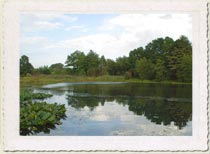
Eibs Pond lies below rolling hills covered by blue stem grass with sweeping views of the Verazzano Bridge and the harbor. The clay-bottomed pond itself covers three acres, making it the largest kettle pond in New York City. Kettle depressions formed from glacial activity occurring 15,000 years ago. Because the only source of water for the pond is rain and runoff, the water level can vary significantly from season to season and year to year. The resulting variety of plant and animal life is quite impressive. The pond is fringed by a cattail (Typha) and arrow arum (Peltandra virginica) marsh, and bulrushes (Scirpus), cinnamon fern (Osmunda cinnamomea), sassafras (Sassafrass albidum), and fragrant water lilies (Nymphaea odorata) all thrive here. Snowy egrets (Egretta thula), bluegill sunfish (Lepomis macrochirus), large-mouth bass (Micropterus dolomieu), painted turtles (Chrysemys picta picta), and muskrats (Ondatra zibethica) all live in or use the pond.
Starting in late June, visitors to Eibs Pond Park can often enjoy a glimpse of monarch butterflies (Danaus plexippus) as they travel through the city. The monarch butterfly lay their eggs on milkweed (Asclepiadaceae) plants and die, entrusting their offspring to fend for themselves. As the larvae gorge themselves on the milkweed leaves, they accumulate the milkweed’s toxic cardiac glycosides and become poisonous to birds and other predators. Monarch butterflies from New York City begin migration in September and travel as much as 2,100 miles to reach their winter destination in central Mexico, in the state of Michoacan, by the end of October.
Photographs
Directions
Public Transit: From the Staten Island Ferry, take the Staten Island Railroad from the St. George terminal and get off at the 4th stop, Grasmere. Walk along Narrows Clove Road (one block from the train stop) Make a right on Targee St and cross under the expressway. Make a right on Mary St and then a right on Hanover. The park entrance is on the left between Mary St and Steuben St. The S76, S74, and x18 (from Brooklyn) travel along Targee St and pass Mary St.
By Car: From the Staten Island Expressway (278) from Brooklyn, take the first exit for Narrows Road North (running parallel to the expressway on the north side). Make a right on Vanderbuilt Ave/Richmond Road. Make a right on Mary Street and then a right on Hanover. The entrance to the park is on the left between Mary St and Steuben St.
Or
From the Staten Island Expressway (278) from Staten Island, take the last exit before the bridge onto Narrows Road South (running parallel to the expressway on the south side). Make a left on Fingerboard Road (over the expressway) and then left onto Narrows Road North. Then follow directions from above.

