Manuel Plaza
Manuel Plaza
What was here before?
Lenapehoking, the homelands of the Lenape, encompassed territory from Connecticut to Delaware. This area was near the village of Sapokanikan, site of a large tobacco farm near Minetta Brook where the Lenape farmed and fished.
In 1629, this area of the island was settled by the Dutch, under the third director of New Netherland, Wouter Van Twiller. The area later became known as the Land of the Blacks, after the first formerly enslaved African persons that were brought here by the Dutch, negotiated for their freedom. Manuel Gerrit de Reus owned the land this plaza sits on.
When the English took over the colony in 1664, they withdrew the rights of the Black population. The New York Slave Codes of 1702 and the anti-Black legislation that banned inheritance of property following the 1712 New York Slave Revolt further limited their freedom.
In the 1830s three upper-class homes were built at 31-35 East Fourth Street. The structures were demolished in 1988 to make way for a residential building that was never built. Next door the Merchant’s House, the Greek Revival style townhouse of Seabury Tredwell (1780-1865), survives as a historic house museum and example of the buildings that once stood here.
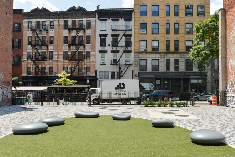
How did this site become a plaza?
In 2022, in partnership with the Department of Environmental Protection (DEP), NYC Parks built this plaza situated on DEP property. Working collaboratively with the community, NYC Parks designed a vest pocket plaza enlivened by multi-colored herringbone paving, a central circular gathering spot with “pebble” seating and a synthetic turf green, as well as perimeter plantings. An opening in the western wall connects to the historic Merchant’s House and permits views of its garden.
Who is this plaza named for?
This site is named in honor of Manuel Gerrit de Reus, Big Manuel, Clyn Manuel, Manuel Sanders, and Manuel Trumpeter. The five Black men were among 28 recipients of land grants in the area earned by people of African descent between 1643 and 1663. Many of them were among the first enslaved Africans brought here by the Dutch West India Company. The mainly farm community is considered by some to be the first Black settlement in what is now New York City.
Manuel Groot, or Big Manuel, was granted eight acres of land located near present-day West 4th Street and Washington Square East towards Bleecker Street and Broadway. Clyn (Little) Manuel held a ten-acre parcel that encompassed a large portion of what is now Mercer Playground. Four acres on the west side of the Bowery near Bleecker and Bond Streets were owned by Manuel Sanders and 18 acres of land near what is now Fifth Avenue and Washington Square North were granted to Manuel Trumpeter.
This name was suggested by Black Gotham Experience, an organization dedicated to highlighting the impact of the African Diaspora in the making of New York.

Check out your park's Vital Signs
Clean & Safe
Green & Resilient
Empowered & Engaged Users
Share your feedback or learn more about how this park is part of a
Vital Park System![]()
 |
%7Cutmcsr%3D(direct)%7Cutmcmd%3D(none)%3B%2B__utmv%3D15173732.-%3B)