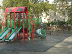
Linwood Playground
Linwood St. bet. New Lots Ave. and Hegeman Ave.
Brooklyn
Directions via Google Maps
Beneath the elevated train tracks and under the jurisdiction of the Metropolitan Transit Authority, this playground shares the property with Elton Playground on the other side of the tracks.
To the Dutch settlers who first laid out village streets in East New York, this area was known as Ostwout, meaning “east woods.” In the 1670s, English farmers began to settle the area as well, intermingling with the Dutch and giving the land the name of New Lots. The area remained primarily rural until 1835, when John Pitkin, a merchant from Connecticut, bought the Ostwout land north of New Lots Avenue and named it East New York in a marketing effort intended to suggest a connection with the metropolis to the west. Linwood Street, formerly known as Monroe Street, was probably laid out in the early- to mid-1800s, and named for President James Monroe (1758-1831).
Show Disclaimer
Highlights
Check out your park's Vital Signs
Clean & Safe
Green & Resilient
Empowered & Engaged Users
Share your feedback or learn more about how this park is part of a
Vital Park System


